

As prepared by the Alaska Redistricting Board on Nov. 10, 2021, the political boundaries for House and Senate districts have shifted to accommodate changing populations.
See if you still live in the same district as you did prior to the adoption of the new map. New districts are created every 10 years after the U.S. Census determines who lives where in America.
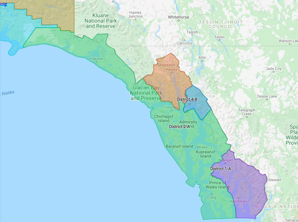
House District 1 – Senate District A – Ketchikan/Wrangell/Metlakatla
House District 1 includes all uplands and islands bounded by a line beginning at the northwestern-most point of the City and Borough of Wrangell, northeast to the Canadian Border, southeast then southwest to the maritime border in the Dixon Entrance, west to the southwestern-most point of the Ketchikan Gateway Borough, north then east the centerline of Clarence Strait west of Annette Island, north to the boundary of the Ketchikan Gateway Borough, north then east to the boundary of the City and Borough of Wrangell, north to a point due east of Eagle Creek, west along a non-visible line to the mouth of Eagle Creek, north along the shoreline to the boundary of the City of Coffman Cove, west then north to the shoreline of Lake Bay, southwest to the entrance of Barnes Lake, west along a non-visible line to Stevenson Island, west along the shoreline to Indian Creek, west along a non-visible line to the western shoreline of Indian Creek, north to the southern shoreline of Whale Passage, north then west to the boundary of the City of Whale Pass, west then north then east to Exchange Cove Road, north to Exchange Creek, north to the western shoreline of Exchange Cove, north to the shoreline of Clarence Strait, northwest to the entrance of an unnamed bay near Lava Creek, north across the entrance to the shoreline of Clarence Strait, north to the entrance of Salmon Bay, north across the entrance to the shoreline of Clarence Strait, north along the shoreline to a non-visible line near Point Colpoys, northeast to the boundary of the City and Borough of Wrangell, northwest to the point of beginning.
See the maps for all the districts at this link:
https://www.google.com/maps/d/embed?mid=1XZ0tEqBV3mBrJcIddPtpK9NV6aO8EK6a
House District 2 – Senate District A – Sitka/Petersburg/Yakutat
House District 2 includes all uplands and islands bounded by a line beginning at the western-most point of Yakutat Borough, northeast then east to Canadian Border, southeast then northeast to the Pacific Glacier Drainage, east to Tarr Inlet, southeast along the southern shoreline to Glacier Bay, south along the shoreline to the entrance of John Hopkins Inlet, southeast across the entrance to the shoreline of Glacier Bay, east to the entrance of Reid Inlet, east across the entrance to the shoreline of Glacier Bay, east then southeast along the shoreline to the entrance of Blue Mouse Cove, southeast across the entrance to an unnamed island, southeast then west along the shoreline to the entrance of Hugh Miller Inlet, south across the entrance to the western shoreline of Glacier Bay, southeast to the entrance of Geikie Inlet, southeast across the entrance to the western shoreline of Glacier Bay, southeast to the entrance of Fingers Bay, southeast to the western shoreline of Glacier Bay, southeast to the entrance of Berg Bay, south across the entrance to the western shoreline of Glacier Bay, south to the entrance of Glacier Bay, east across the entrance to the eastern shoreline of Glacier Bay, east along the shoreline to the boundary of the City of Gustavus, south then east to the shoreline of Pleasant Island, northeast then southeast to the eastern entrance to Icy Passage, northeast to the boundary of Glacier Bay National Park, east to the boundary of Haines Borough, southeast then north to the boundary of the City and Borough of Juneau, southeast then south then northeast then southeast then northeast along the
boundary to the Canadian Border, southeast to the northern boundary of the City and Borough of Wrangell, southwest then southeast to a non-visible line across Clarence Strait from Point Colpoys, west along a non-visible line to the shoreline near Point Colpoys, southeast to entrance of Salmon Bay, south across the entrance to the shoreline of Clarence Strait, south to the entrance of an unnamed bay near Lava Creek, south across the entrance to the shoreline of Clarence Strait, southeast to Exchange Cove, south along the western shoreline to Exchange Creek, south to Exchange Cove Road, south to the boundary of the City of Whale Pass, west then south then east to the southern shoreline of Whale Passage, east then south to the western shoreline of Indian Creek, south to Barnes Lake, east along a non-visible line to Stevenson Island, east then north along the shoreline to Lake Bay, east across a non- visible line to the eastern shoreline of Lake Bay, northeast to the boundary of the City of Coffman Cove, south then east to the western shoreline of Clarence Strait, south to the mouth of Eagle Creek, northeast along a non-visible line to the boundary of the City and Borough of Wrangell, southeast to the boundary of the Ketchikan Gateway Borough, south to the centerline of Clarence Strait west of Annette Island, south to the boundary of the Ketchikan Gateway Borough, south to the maritime border in the Dixon Entrance, west to the 3-mile limit in the Pacific Ocean near Forrester Island, north along the 3- mile limit to the boundary of the City and Borough of Sitka, northwest along the boundary to the 3-mile limit in the Pacific Ocean near Yakobi Island, northwest along the 3-mile limit to the boundary of Yakutat Borough, northwest to the point of beginning.
House District 3 – Senate District B – Mendenhall Valley/Haines/Skagway/Gustavus
House District 3 includes all uplands and islands bounded by a line beginning at the intersection of the northern edge of the Juneau Icefield and the Canadian Border, northwest then southwest along the border to the Pacific Glacier Drainage, east to Tarr Inlet, southeast along the southern shoreline to Glacier Bay, south along the shoreline to the entrance of John Hopkins Inlet, southeast across the entrance to the shoreline of Glacier Bay, east to the entrance of Reid Inlet, east across the entrance to the shoreline of Glacier Bay, east then southeast along the shoreline to the entrance of Blue Mouse Cove, southeast across the entrance to an unnamed island, southeast then west along the shoreline to the entrance of Hugh Miller Inlet, south across the entrance to the western shoreline of Glacier Bay, southeast to the entrance of Geikie Inlet, southeast across the entrance to the western shoreline of Glacier Bay, southeast to the entrance of Fingers Bay, southeast to the western shoreline of Glacier Bay, southeast to the entrance of Berg Bay, south across the entrance to the western shoreline of Glacier Bay, south to the entrance of Glacier Bay, east across the entrance to the eastern shoreline of Glacier Bay, east along the shoreline to the boundary of the City of Gustavus, south then east to the shoreline of Pleasant Island, northeast then southeast to the eastern entrance to Icy Passage, northeast to the boundary of Glacier Bay National Park, east to the boundary of Haines Borough, southeast then north to the boundary of the City and Borough of Juneau, south to a non-visible line extending southwest from the centerline of Fritz Cove, northeast to the centerline of Fritz Cove, northeast to the entrance of Gastineau Channel, north to the mouth of the Mendenhall River, north along the eastern bank of the Mendenhall River to the mouth of Duck Creek, east to Mendenhall Refuge Access Road, north to Radcliffe Road, north to the Glacier Highway, west to Vintage Boulevard, north then east to Riverside Drive, north to Stephen Richards Memorial Drive, east to Haloff Way, east to Tongass Boulevard, south to Jennifer Drive, east to the end of Jennifer Drive, south along a non-visible line to the Jorden Creek Tributary, northeast then southeast to Heintzleman Ridge, northeast to a non-visible line near the headwaters of Steep Creek, northeast to the headwaters of Steep Creek, northwest to Glacier Spur Road, northwest to a non-visible line near Mendenhall Lake, northwest to the shoreline of Mendenhall Lake, north then south then west to Mendenhall Glacier, west then north along the western edge of Mendenhall Glacier to the Juneau Icefield, west then north along the northern edge of the Juneau Icefield to the point of beginning.
House District 4 – Senate District B – Downtown Juneau/Douglas/Juneau Airport
House District 4 includes all uplands and islands bounded by a line beginning at the intersection of the Canadian Border and the southern boundary of the City and Borough of Juneau, southwest then northwest then southwest then north to a non-visible line extending southwest from the centerline of Fritz Cove, northeast to the centerline of Fritz Cove, northeast to the entrance of Gastineau Channel, north to the mouth of the Mendenhall River, north along the eastern bank of the Mendenhall River to the mouth of Duck Creek, east to Mendenhall Refuge Access Road, north to Radcliffe Road, north to the Glacier Highway, west to Vintage Boulevard, north then east to Riverside Drive, north to Stephen Richards Memorial Drive, east to Haloff Way, east to Tongass Boulevard, south to Jennifer Drive, east to the end of Jennifer Drive, south along a non-visible line to the Jorden Creek Tributary, northeast then southeast to Heintzleman Ridge, northeast to a non-visible line near the headwaters of Steep Creek, northeast to the headwaters of Steep Creek, northwest to Glacier Spur Road, northwest to a non-visible line near Mendenhall Lake, northwest to the shoreline of Mendenhall Lake, north then south then west to Mendenahll Glacier, west then north along the western edge of Mendenhall Glacier to the Juneau Icefield, west then north along the northern edge of the Juneau Icefield to the Canadian Border, than southeast to the point of beginning.
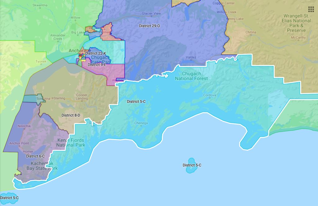
House District 5 – Senate District C – Kodiak/Seward/Cordova
House District 5 includes all uplands and islands bounded by a line beginning at the intersection of the Chugach ANRC and the western boundary of the Wrangell-Saint Elias National Park, south along the park boundary to the boundary of the Chugach National Forest, west to a non-visible line extending east from the headweaters of the Lowe River, west along a non-visible line to the headwaters of the Lowe River, west to a non-visible line extending south from the Trans-Alaska Pipeline east of the boundary of the City of Valdez, north along a non-visible line to the Trans-Alaska Pipeline, west to boundary of the City of Valdez, south then west then north to the boundary of the Chugach National Forest on the northern shoreline of Valdez Arm, west to the entrance of Sawmill Bay, west across the entrance to the boundary of the Chugach National Forest, southwest then west to the entrance of Columbia Bay, west across the entrance to the shoreline of Prince William Sound, west to the entrance of an unnamed bay east of Long Point, west across the entrance to the shoreline of Prince William Sound, west to the entrance of Long Channel, west across the entrance to the shoreline near Buyers Cove, southwest to a non-visible line extending northwest from Glacier Island, southeast along on non-visible line to the shoreline of Glacier Island, east along the shoreline to a non-visible line extending west from the northern-most point of Growler Island, east to Growler Island, east along a non-visible line to the shoreline of Glacier Island, south then west to the western-most point of Glacier Island, west to a peninsula of Land near Fairmount Bay, southwest to the entrance of a small bay, southwest across the entrance to the shoreline of Prince William Sound, southwest then north then northwest to the entrance of a small unnamed bay east of Fairmount Bay, northwest across the entrance to the shoreline, west to the entrance of Fairmount Bay, west across the entrance to a non-visible line extending north from Fairmount Island, south along a non- visible line to Fairmount Island, southeast then south then west then north to a non-visible line extending south from Fairmount Point, north the shoreline near Fairmount Point, north to the entrance of Wells Bay, west across the entrance to the shoreline near Unakwik Point, south then west to the entrance of Unakwik Inlet, southwest across the entrance to the shoreline north of Olsen Cove, south to a non-visible line extending west from Olsen Island, east to the shoreline of Olsen Island, northeast then southeast then south the west to a non-visible line extending east from south of Olsen Cove, west to the shoreline south of Olsen Cove, south then west to a small bay north of Kiniklik Island, west across the entrance to the shoreline, west the entrance of a small bay northwest of Kiniklik Island, west across the entrance to the shoreline, west to the entrance of Eaglek Bay, southwest across the entrance to the shoreline of island west of Eaglek Island, southwest then west to the western entrance of Eaglek Bay, west across the entrance to the shoreline, southwest then west to the entrance of a small cove east of Squaw Bay, west across the entrance to the shoreline, west to the entrance of a unnamed bay east of Squaw Bay, west across the entrance, west to the entrance of a small cove east of Squaw Bay, west across the entrance to the shoreline, northwest to the entrance of Squaw Bay, northwest across the entrance to the shoreline, west to the entrance of a small cove east of Esther Bay, west across the entrance to the shoreline, west to the entrance of a small cove east of Esther Bay, west across the entrance to the shoreline, west to the entrance of Esther Bay, west across the entrance to the shoreline, south then southwest to the entrance of Esther Passage, southwest across the entrance to the shoreline, southwest then west to the entrance of Quillian Bay, southwest across the entrance to the shoreline, west to the entrance of Lake Bay, west across the entrance to the shoreline, west to the eastern shoreline of Port Wells, west along a non-visible line to the western shoreline of Port Wells east of Entry Cove, west to the entrance of Entry Cove, west across the entrance to the shoreline, west to the entrance of Passage Canal, west across the entrance to the shoreline, south then west to the boundary of the City of Whittier, south then west to the boundary of the Municipality of Anchorage, south to the boundary of the Kenai Peninsula Borough, east then south to the southern boundary of the Chugach National Forest, west then south then southwest then west to the boundary of the City of Seward, north then northwest then south to Lowell Creek, west to the headwaters of Lowell Creek, north along a non- visible line to the boundary of Kenai Fjords National Park, northwest to the boundary of Chugach ANRC, south to the boundary of Kenai Fjords National Park, southwest then east then south to the shoreline of Nuka Passage, southwest to the entrance of Tonsina Bay, south across the entrance to shoreline of Nuka Passage, south to the shoreline of the Gulf of Alaska, south the entrance of an unnamed bay, south across the entrance to the shoreline near Gore Point, west to the entrance of Port Dick, west across the entrance to the shoreline of the Gulf of Alaska, west to the entrance of Touglaalek Bay, west across the entrance to the shoreline of the Gulf of Alaska, west to the entrance of Qikutulig Bay, west across the entrance to entrance of Rocky Bay, west across the entrance to the shoreline of the Gulf of Alaska, west to the entrance of an unnamed bay, west across the entrance to the shoreline of the Gulf of Alaska, southwest to the entrance of Chugach Bay, southwest across the entrance to the shoreline of Chugach Passage, west then north to the entrance of Port Chatham, northwest across the entrance to shoreline of Chugach Passage, northwest to the entrance of Koyuktolik Bay, northwest across the entrance to the shoreline of Kennedy Entrance, northwest along the shoreline to the western edge of Kennedy Entrance, south along the western edge of Kennedy Entrance to the 3-mile limit south of Elizabeth Island, southwest then southeast the northeast around all of the Barren Islands and Afogak Island and Kodiak Island and the Trinity Islands to the southern boundary of the Kenai Peninsula Borough near East Chugach Island, northeast along the southern boundary to the 3-mile limit of the Pacific Ocean south of Whidbey Bay, east along the along the 3-mile limit of the Pacific Ocean including Middleton Island to the boundary of Yakutat Borough, north then northeast then east to the boundary of Chugach ANRC, northwest to the point of beginning.
House District 6 – Senate District C – Kachemak Bay/Ninilchik/Kasilof
House District 6 is bounded by a line beginning at the intersection of Slikok Creek and the Sterling Highway, south along the highway to Wolverine Avenue, east then south to the end of Wolverine Avenue, south along an unnamed path to Heavy Down Drive, south to western branch of Coal Creek, southwest to the confluence with the eastern branch of Coal Creek, east to a non-visible line extending north from the western boundary of the Kenai National Wildlife Refuge, south to the boundary of the Kenai National Wildlife Refuge, south the west to the northern bank of the Kasilof River, southeast along the northern bank to Tustumena Lake, northeast then southeast to Glacier Creek, southeast to Tustamena Glacier, east along the northern edge of the glacier to the Harding Icefield, south to a non- visible line extending northwest from the boundary of Chugach ANRC, southeast to the Chugach ANRC, south to the boundary of Kenai Fjords National Park, southwest then east then south to shoreline of
Nuka Passage, southwest to the entrance of Tonsina Bay, south across the entrance to shoreline of Nuka Passage, south to the shoreline of the Gulf of Alaska, south to the entrance of an unnamed bay, south across the entrance to the shoreline near Gore Point, west to the entrance of Port Dick, west across the entrance to the shoreline of the Gulf of Alaska, west to the entrance of Touglaalek Bay, west across the entrance to the shoreline of the Gulf of Alaska, west to the entrance of Qikutulig Bay, west across the entrance to entrance of Rocky Bay, west across the entrance to the shoreline of the Gulf of Alaska, west to the entrance of an unnamed bay, west across the entrance to the shoreline of the Gulf of Alaska, southwest to the entrance of Chugach Bay, southwest across the entrance to the shoreline of Chugach Passage, west then north to the entrance of Port Chatham, northwest across the entrance to shoreline of Chugach Passage, northwest to the entrance of Koyuktolik Bay, northwest across the entrance to the shoreline of Kennedy Entrance, northwest to the shoreline of Cook Inlet, north to an unnamed creek north of Point Bede, east to the headwaters of the unnamed creek, south along a non-visible line to the Mount Bede Ridgeline, southeast to an unnamed creek, northeast to an unnamed lake along the English Bay River, north to the outlet of the lake, east to an unnamed creek, north to the shoreline of Port Graham, east then north then northwest to the shoreline of Cook Inlet, north the entrance of Kachemak Bay, north across the entrance to a non-visible line extending east from the centerline of Cook Inlet, west to the centerline of Cook Inlet, north to a non-visible line extending west from the shoreline near Oil Company Haul Road, east to the shoreline of Cook Inlet, east along a non-visible line to Oil Company Haul Road, south to the end of Oil Company Haul Road, southeast along a non-visible line to Gas Well Road, east then northeast to a non-visible line extending west from Harmony Avenue, east to Harmony Avenue, northeast to Echo Lake Road, south to Evelyn Lane, east to the end of Evelyn Lane, east along a non-visible line to Slikok Creek, southeast to the point of beginning.
House District 7 – Senate District D – Kenai/Soldotna
House District 7 is bounded by a line beginning at the northwestern most point of the City of Kenai, east then south to the Kenai Spur Highway, south to Sports Lake Road, east to Moser Street, south to the end of Moser Street, south along a non-visible line to Alaska Natural Gas Pipeline ROW, east to a non-visible line extending north from boundary of the City of Soldotna, south to the boundary of the City of Soldotna, east then south to the northern bank of the Kenai River, southeast to the boundary of the Kenai National Wildlife Refuge, west to the boundary of the City of Soldotna near the Sterling Highway, west along the boundary to Gas Well Road, west to Echo Lake Road, south to Harmony Avenue, southwest to the end of Harmony Avenue, west along a non-visible line to Gas Well Road, southwest then west to the end of Gas Well Road, northwest along a non-visible line to Oil Company Haul Road, northwest to a non-visible line near Kalifornsky Beach Road, west along the non-visible line to the shoreline of Cook Inlet, west along a non-visible line to the centerline of Cook Inlet, north to a non- visible line extending west from the northern boundary of the City of Kenai, east to the point of beginning.
House District 8 – Senate District D – Northern Kenai Peninsula
House District 8 is bounded by a line beginning at the intersection of the Kenai Peninsula Borough with both the Matansuska-Susitna Borough and the Municipality of Anchorage, southwest along the Kenai Peninsula Borough boundary to the centerline of Cook Inlet, southwest then south to a non-visible line extending west from the northern boundary of the City of Kenai, east to the boundary of the City of Kenai, east then south to the Kenai Spur Highway, south to Sports Lake Road, east to Moser Street, south to the end of Moser Street, south along a non-visible line to Alaska Natural Gas Pipeline ROW, east to a non-visible line extending north from boundary of the City of Soldotna, south to the boundary of the City of Soldotna, east then south to the northern bank of the Kenai River, southeast to the boundary of the Kenai National Wildlife Refuge, west to the boundary of the City of Soldotna near the
Sterling Highway, west along the boundary to Gas Well Road, west to Echo Lake Road, south to Evelyn Lane, east to the end of Evelyn Lane, east along a non-visible line to Slikok Creek, southeast to the Sterling Highway, south along the highway to Wolverine Avenue, east then south to the end of Wolverine Avenue, south along an unnamed path to Heavy Down Drive, south to western branch of Coal Creek, southwest to the confluence with the eastern branch of Coal Creek, east to a non-visible line extending north from the western boundary of the Kenai National Wildlife Refuge, south to the boundary of the Kenai National Wildlife Refuge, south then west to the northern bank of the Kasilof River, southeast along the northern bank of the Kasilof River, to Tustumena Lake, northeast then southeast to Glacier Creek, southeast to Tustamena Glacier, east along the northern edge of the glacier to the Harding Icefield, north to a non-visible line extending northwest from the boundary of the Chugach ANRC, east then north then northwest to the Chugach ANRC, northeast to the boundary of Kenai Fjords National Park along the Resurrection River, southeast to the eastern boundary of the park, south along a non-visible line to the headwaters of Lowell Creek, east to the boundary of the City of Seward, north then east then south to the boundary of the Chugach National Forest, east then northeast then east to the boundary of the Kenai Peninsula Borough, north then northwest to the point of beginning.
House District 9 – Senate District E – South Anchorage/Turnagain Arm/Whittier
House District 9 is bounded by a line beginning at the intersection of the New Seward Highway and Huffman Road, east on Huffman Road to Birch Road, northeast then south to Huffman Road, east to Upper Huffman Road, east to Sultana Drive, northeast then east to the boundary of Chugach State Park, north to Basher Drive, southwest to the boundary of Far North Bicentennial Park, north to the boundary of Fort Richardson, east to the boundary of Chugach State Park, east then southeast to a non-visible line extending north from the powerlines near the headwaters of the south fork of Campbell Creek, south along the non-visible line to the powerlines, east along a non-visible line to Ship Creek, east then northeast to the headwaters of Ship Creek, southeast along a non-visible line to the ridgeline between Bird Creek and Raven Creek, southeast to the boundary of the Chugach National Forest, north then east to the boundary of the Municipality of Anchorage, south then west then south to the northern boundary of the City of Whittier, east then south then west along the city boundary to the boundary of the Municipality of Anchorage, south then west then north then northwest to a non-visible line extending south from the mouth of Little Rabbit Creek, north to the mouth of Little Rabbit Creek, east to the New Seward Highway, north to the point of beginning.
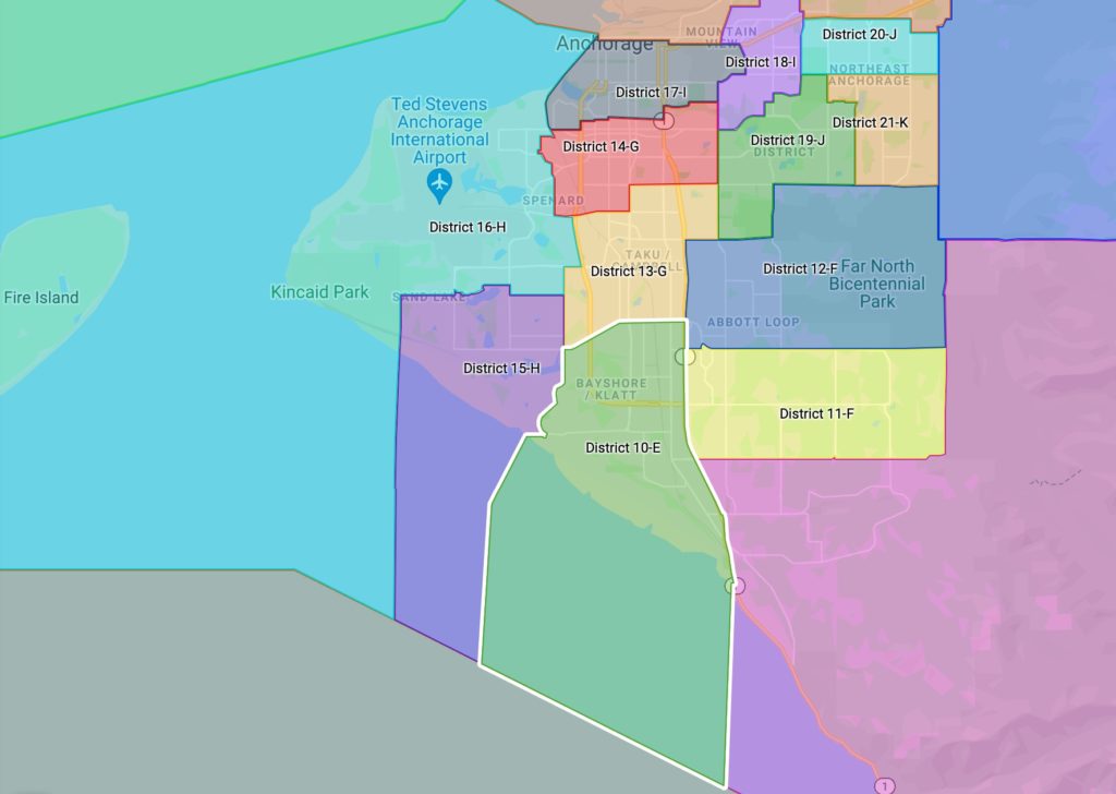
House District 10 – Senate District E – Oceanview/Klatt
House District 10 is bounded by a line beginning at the intersection of the New Seward Highway and Dimond Boulevard, west on Dimond Boulevard to Victor Road, south to Southport Drive, south to Diligence Circle, south to Crow’s Nest Circle, west to the end of Crow’s Nest Circle, west along a non- visible line to the shoreline of Turnagain Arm, southwest then south along a non-visible line to the boundary of the Municipality of Anchorage, southeast to a non-visible line extending south from the mouth of Little Rabbit Creek, north to the mouth of Little Rabbit Creek, east to the New Seward Highway, north to the point of beginning.
House District 11 – Senate District F – Lower Hillside
House District 11 is bounded by a line beginning at the intersection of the New Seward Highway and Huffman Road, east on Huffman Road to Birch Road, northeast then south to Huffman Road, east to
Upper Huffman Road, east to Sultana Drive, northeast then east to the boundary of Chugach State Park, north to the boundary of Far North Bicentennial Park, west to the boundary of Hillside Park, west to Abbott Road, west then northwest to Vanguard Drive, southwest then south to Academy Drive, west to the end of Academy Drive, west along a non-visible line to the New Seward Highway, south to the point of beginning.
House District 12 – Senate District F – Far North Bicentennial Park
House District 12 is bounded by a line beginning at the intersection of Elmore Road and Tudor Road, east on Tudor Road to the boundary of Far North Bicentennial Park, east then south then west to the boundary of Hillside Park, west to Abbott Road, west then northwest to Vanguard Drive, southwest then south to Academy Drive, west to the end of Academy Drive, west along a non-visible line to the New Seward Highway, north to E Dowling Road, east to Elmore Road, north to the point of beginning.
House District 13 – Senate District G – Campbell
House District 13 is bounded by a line beginning at the intersection of Dowling Road and the New Seward Highway, south on the New Seward Highway to Dimond Boulevard, west then southwest to Northwood Street, north to Raspberry Road, east to Minnesota Drive, north to International Airport Road, east to C St, north to Tudor Road, east to Lake Otis Parkway, south to Dowling Road, west to the point of beginning.
House District 14 – Senate District G – Spenard
House District 14 is bounded by a line beginning at the intersection of Tudor Road and C Street, south on C Street to International Airport Road, west on International Airport Road to Northwood Drive, north to Iowa Drive, north to McRae Road, northwest to Turnagain Street, north to W 34th Avenue, east to Turnagain Street, north to W 30th Avenue, east to Fish Creek, north then east to the Alaska Railroad, northwest to Northern Lights Boulevard, east to Minnesota Drive, north to W 26th Avenue, east to Spenard Road, north to W 25th Avenue, east to Arctic Boulevard, north to Fireweed Lane, east to the New Seward Highway, north to Chester Creek, east to the north fork of Chester Creek, north to E 20th Avenue, east to Lake Otis Parkway, south to Tudor Road, west to the point of beginning.
House District 15 – Senate District H – Sand Lake/Campbell Lake
House District 15 is bounded by a line beginning at the intersection of Strawberry Road and Northwood Street, south on Northwood Street to Victor Road, south to Southport Drive, south to Diligence Circle, south to Crow’s Nest Circle, west to the end of Crow’s Nest Circle, west along a non-visible line to the shoreline of Turnagain Arm, southwest then south along a non-visible line to the boundary of the Municipality of Anchorage, northwest to a non-visible line extending south from the eastern boundary of Kincaid Park, north along a non-visible line to the boundary of Kincaid Park, north to Jodhpur Street, north to Kincaid Road, east to Sand Lake Road, north to Wandering Drive, southeast then east then south to Kincaid Road, east to Sportsman Drive, east to Sandy Beach Drive, northeast to Silver Birch Drive, north to Caravelle Drive, east to Jewel Lake Road, south to Strawberry Road, east to the point of beginning.
House District 16 – Senate District H – Anchorage Airport
House District 16 is bounded by a line beginning at the intersection of Minnesota Drive and International Airport Road, west on International Airport Road to Northwood Drive, north to Iowa Drive, north to McRae Road, northwest to Turnagain Street, north to W 34th Avenue, east to Turnagain Street, north to W 30th Avenue, east to Fish Creek, north then east to the Alaska Railroad, north then northeast to a non-visible line extending east near W 2nd Avenue, west on the non-visible line to the shoreline of Knik Arm, west then northwest along a non-visible line to the boundary of the Municipality of Anchorage, southwest then southeast then south then southeast to a non-visible line extending south from the eastern boundary of Kincaid Park, north along a non-visible line to the boundary of Kincaid Park, north to Jodhpur Street, north to Kincaid Road, east to Sand Lake Road, north to Wandering Drive, southeast then east then south to Kincaid Road, east to Sportsman Drive, east to Sandy Beach Drive, northeast to Silver Birch Drive, north to Caravelle Drive, east to Jewel Lake Road, south to Strawberry Road, east to Northwood Street, north to Raspberry Road, east to Minnesota Drive, north to the point of beginning.
House District 17 – Senate District I – Downtown Anchorage
House District 17 is bounded by a line beginning at the intersection of E 4th Avenue and Juneau Street, south on Juneau Street to E 5th Avenue, east to Airport Heights Drive, south to Debarr Road, west to Lake Otis Parkway, south to E 20th Avenue, west to the north fork of Chester Creek, south to Chester Creek, west to the New Seward Highway, south to Fireweed Lane, west to Arctic Boulevard, south to W 25th Avenue, west to Spenard Road, south to W 26th Avenue, west to Minnesota Drive, south to Northern Lights Boulevard, west to the Alaska Railroad, north then northeast to a non-visible line extending north from the end of L Street, south to L Street, south to W 4th Avenue, east to the point of beginning.
House District 18 – Senate District I – Mountainview/Airport Heights
House District 18 is bounded by a line beginning at the intersection of Lake Otis Parkway and E Northern Lights Boulevard, east on E Northern Lights Boulevard to Nichols Street, north to E 20th Avenue, east to Bragaw Street, north to Reka Drive, east to the powerlines extending south from Pine Street, north to Pine Street, north to McCarrey Street, north to Mountainview Drive, west to N Pine Street, north to McPhee Avenue, west to the boundary of Elmendorf Air Force Base, southwest then south to Taylor Street, south to Thompson Avenue, west to the boundary of Elmendorf Air Force Base, west to Reeve Boulevard, south to E 5th Avenue, east to Airport Heights Drive, south to Debarr Road, west to Lake Otis Parkway, south to the point of beginning.
House District 19 – Senate District J – U-Med
House District 19 is bounded by a line beginning at the intersection of Lake Otis Parkway and Northern Lights Boulevard, east on Northern Lights Boulevard to Nichols Street, north to E 20th Avenue, east to Bragaw Street, north to Reka Drive, east to the powerlines extending south from Pine Street, north to Pine Street, north to Debarr Road, east to Boniface Parkway, south to a non-visible line extending west from E 20th Avenue, east to E 20th Avenue, east to Penn Circle, north to Craig Drive, east to the end of Craig Drive, southeast along a non-visible line to the southern boundary of Nunaka Valley Park, east to Beaver Place, south to Baxter Road, south to Tudor Road, west to Elmore Road, south to Dowling Road, west to Lake Otis Parkway, north to the point of beginning.
House District 20 – Senate District J – North Muldoon
House District 20 is bounded by a line beginning at the intersection of Debarr Road and Pine Street, north on Pine Street to McCarrey Street, north to the Glenn Highway, east to a non-visible line extending north from Boundary Avenue near Patterson Street, south along a non-visible line to Boundary Avenue, east to Muldoon Road, south to Duben Avenue, east to the boundary of Fort Richardson, south to a non-visible line extending east from the end of Debarr Road, west along a non- visible line to Debarr Road, west to a non-visible line extending east from Debarr Road and Muldoon Road, west along a non-visible line to Debarr Road, west to the point of beginning.
House District 21 – Senate District K – South Muldoon
House District 21 is bounded by a line beginning at the intersection of Debarr Road and Boniface Parkway, south on Boniface Parkway to a non-visible line extending west from E 20th Avenue, east to E 20th Avenue, east to Penn Circle, north to Craig Drive, east to the end of Craig Drive, southeast along a non-visible line to the southern boundary of Nunaka Valley Park, east to Beaver Place, south to Baxter Road, south to Tudor Road, east along the north boundary of Far North Bicentennial Park, east to the boundary of Fort Richardson, north to a non-visible line extending east from the end of Debarr Road, west along a non-visible line to Debarr Road, west to a non-visible line extending east from Debarr Road and Muldoon Road, west along a non-visible line to Debarr Road, west to the point of beginning.
House District 22 – Senate District K – Eagle River Valley
House District 22 is bounded by a line beginning at the intersection of Eagle River Loop Road and Lazy Street, south on Lazy Street to Easy Street, west to the Old Glenn Highway, south then west to Mausel Street, then north to Artillery Road, west then north then west to the boundary of Fort Richardson, south to the Glenn Highway, southwest to the western boundary of Fort Richardson, south then west to a non-visible line extending northeast from the end of Peck Avenue, southwest to Peck Avenue, southwest then west to the boundary of Fort Richardson, south then east to the boundary of Chugach State Park, east then southeast to a non-visible line extending north from the powerlines near the headwaters of the south fork of Campbell Creek, south along the non-visible line to the powerlines, east along a non-visible line to Ship Creek, east then northeast to the headwaters of Ship Creek, southeast along a non-visible line to the ridgeline between Bird Creek and Raven Creek, southeast to the boundary of the Chugach National Forest, north then east to the ridgeline between Eagle River and Peters Creek, northwest along the ridgeline to a non-visible line extending east from the headwaters of Meadow Creek, west along a non-visible line to the headwaters of Meadow Creek, northwest to a non-visible line extending north from the boundary of Chugach State Park, south along a non-visible line to the boundary of Chugach State Park, west to Steeple Drive, southwest to Eagle River Lane, south to War Admiral Road, northwest then west to Sun Beau Drive, southwest to Eagle River Loop Road, north then northwest to the point of beginning.
House District 23 – Senate District L – Government Hill/JBER/Northeast Anchorage
House District 23 is bounded by a line beginning at the intersection of the Glenn Highway and McCarrey Street, north on McCarrey Street to Mountainview Drive, west to Pine Street, north to McPhee Avenue, west to the boundary of Elmendorf Air Force Base, west then south to Taylor Street, south to Thompson Avenue, west to the boundary of Elmendorf Air Force Base, west to Reeve Boulevard, south to E 5th Avenue, west to Juneau Street, north to E 4th Avenue, west to L Street, north to the end of L Street, north along a non-visible line to the Alaska Railroad, northeast to a non-visible line extending east near W 2nd Avenue, west on the non-visible line to the shoreline of Knik Arm, west then northwest along a
non-visible line to the boundary of the Municipality of Anchorage, north to the northern boundary of Elmendorf Air Force Base, southeast then south then east then south to Loop Road, east to the Alaska Railroad, east then northeast to Fossil Creek, east then northeast to the boundary of Fort Richardson, north then east to the Glenn Highway, southwest to the western boundary of Fort Richardson, south then west to a non-visible line extending northeast from the end of Peck Avenue, southwest to Peck Avenue, southwest then west to the boundary of Fort Richardson, south to Duben Avenue, west to Muldoon Road, north to Boundary Avenue, west to a non-visible line extending north from Patterson Street, north along a non-visible line to the Glenn Highway, west to the point of beginning.
House District 24 – Senate District L – North Eagle River/Chugiak
House District 24 is bounded by a line beginning at the intersection of Sun Beau Drive and Eagle River Loop Road, north then northwest on Eagle River Loop Road to Lazy Street, south to Easy Street, west to the Old Glenn Highway, south then west to Mausel Street, then north to Artillery Road, west then north then west to the boundary of Fort Richardson, south then west then southwest along the boundary of Fort Richardson to Fossil Creek, west to the Alaska Railroad, west then southwest to Loop Road, north then northwest then west to the boundary of Elmendorf Air Force Base, north then west then north then west to the boundary of the Municipality of Anchorage, northeast then east then south then east then south to the boundary of the Chugach National Forest, west to the ridgeline between Eagle River and Peters Creek, northwest along the ridgeline to a non-visible line extending east from the headwaters of Meadow Creek, west along a non-visible line to the headwaters of Meadow Creek, northwest to a non-visible line extending north from the boundary of Chugach State Park, south along a non-visible line to the boundary of Chugach State Park, west to Steeple Drive, southwest to Eagle River Lane, south to War Admiral Road, northwest then west to Sun Beau Drive, southwest to the point of beginning.
House District 25 – Senate District M – Palmer/Butte
House District 25 is bounded by a line beginning at the intersection of the Glenn Highway and the boundary of the Municipality of Anchorage, east then southeast then east to Glacier Fork, northwest to Metal Creek, southwest to the Knik River, west along the northern bank of the Knik River to the confluence with Jim Creek, northeast then east then south then north then south then west around the headwaters of Jim Creek to the confluence with McRoberts Creek, northwest to a small stream near Jim Lake, northeast to the shoreline of Jim Lake, south then east then north to an unnamed creek on the northeast side of the lake, northeast to the headwaters, northeast along a non-visible line to the ridgeline, northeast to a non-visible line extending southeast from a tributary of Wolverine Creek, northwest to a tributary of Wolverine Creek, northeast to its confluence with Wolverine Creek, northeast along a non-visible line to headwaters of an unnamed creek, northwest to the Matanuska River, west along a non-visible line to the northern bank of the Matanuska River east of Eska Creek, southwest to a non-visible line east of E Collier Road, west along a non-visible line to the Glenn Highway, south to N Farm Loop Road, west then south to Fence Line Drive, southeast to Monte Carlo Lane, south to E Biscane Drive, west to N Ryder Drive, south to N Palmer-Fishhook Road, west then northwest to N Trunk Road, southwest to E Bogard Road, east to 49th Street, south to E Palmer-Wasilla Highway, east to a non-visible line east of Loma Prieta Drive, south along a non-visible line Grandview Drive, southeast then southwest to a non-visible line north of Rabbit Slough, southeast to the western bank of the Matanuska River, south along the western bank to the Glenn Highway, south to the point of beginning.
House District 26 – Senate District M– Goose Bay/Gateway
House District 26 is bounded by a line beginning at the intersection of the eastern boundary of the City of Wasilla and the Parks Highway, east along the Parks Highway to S Trunk Road, north to N Old Trunk Road, north to E Palmer-Wasilla Highway, east to a non-visible line east of Loma Prieta Drive, south along a non-visible line to Grandview Drive, southeast then southwest to a non-visible line north of Rabbit Slough, southeast to the western bank of the Matanuska River, south along the western bank to the Glenn Highway, south to the boundary of the Matanuska-Susitna Borough, west then southwest to a non-visible line extending south from the mouth of Crocker Creek, north to the mouth of Crocker Creek, northeast to Settlers Bay Drive, northwest to Crocker Creek, west then north to S Settlers Bay Drive, northeast then northwest to S Knik-Goose Bay Road, southwest to Carmel Road, west to S Aurora Drive, south then west to S Northern Lights Drive, south to Shearwater Street, west to Hallie Drive, north to W Carmel Road, west to the end of W Carmel Road, west along a non-visible line to an unnamed creek north of Threemile Lake, northeast to a non-visible line extending south from S Pond Lily Lane, north to S Pond Lily Lane, north to non-visible line extending south from Whale Lake, north along a non-visible line to Whale Lake, west then northeast along the shoreline to a non-visible line extending north to a unnamed lake, north along a non-visible line to an unnamed lake, east then north then west to a non- visible line extending south from Lucille Creek, north along a non-visible line to Lucille Creek, east to a non-visible line extending south from the boundary of the City of Houston east of W Eastwind Circle, north along a non-visible line to the boundary of the City of Houston, east then north to the Parks Highway, east to W Buttercup Drive, east to Sylvan Road, south to W Dun Fussin Road, east to a non- visible line east of Sylvan Road, south along a non-visible line to an unnamed lake north of Lucille Creek, west then south then east to a non-visible line extending north from Lucille Creek, south along a non- visible line to Lucille Creek, east to Vine Road, south to Bonaparte Avenue, east to S Rue de la Paix Loop, north to W Montclaire Avenue, east to W Lollybrock Drive, north then east to Foothills Boulevard, south to W Ronnies Circle, east then south to Overby Street, east then northeast to Saindon Street, east to Donovan Drive, northeast to S Clapp Street, south to Knik-Goose Bay Road, northeast to the boundary of the City of Wasilla, east then north along the city boundary to the point of beginning.
House District 27 – Senate District N – Wasilla/Meadow Lakes
House District 27 is bounded by a line beginning at the intersection of the City of Houston and the Parks Highway, east to W Buttercup Drive, east to Sylvan Road, south to W Dun Fussin Road, east to a non- visible line east of Sylvan Road, south along a non-visible line to an unnamed lake north of Lucille Creek, west then south then east to a non-visible line extending north from Lucille Creek, south along a non- visible line to Lucille Creek, east to Vine Road, south to Bonaparte Avenue, east to S Rue de la Paix Loop, north to W Montclaire Avenue, east to W Lollybrock Drive, north then east to Foothills Boulevard, south to W Ronnies Circle, east then south to Overby Street, east then northeast to Saindon Street, east to Donovan Drive, northeast to S Clapp Street, south to Knik-Goose Bay Road, northeast to the boundary of the City of Wasilla, east then north then west then south then west then northwest then north then east then north then east around the city boundaries to Church Road, north to Shampine Avenue, east to N Sandhill Crane Street, north to W Trumpeter Swan Avenue, east then north to W Woodpecker Circle, east to N Infinite Road, north to the intersection with W Schrock Road, north along a non-visible line to the northern bank of the Little Susitna River, west along the northern bank to the boundary of the City of Houston, south to the point of beginning.
House District 28 – Senate District N – Tanaina/Lakes
House District 28 is bounded by a line beginning at the intersection of N Trunk Road and E Bogard Road, to E Seldon Road, then west along E Bogard Road to Wasilla-Fishhook Road, northeast to a non-visible
line extending from near E Polar Bear Drive, north then west then south along a non-visible line to the eastern end of Burlwood Drive, west to E Schrock Road, north then southwest to N Infinite Road, south to W Woodpecker Circle, west to W Trumpeter Swan Avenue, south then west to N Sandhill Crane Street, south to Shampine Avenue, west to Church Road, south to the boundary of the City of Wasilla, east then south then east then south then southeast then north then east then south to the Parks Highway, east to S Trunk Road, north to N Old Trunk Road, north to E Palmer-Wasilla Highway, east to 49th Street, north to E Bogard Road, west to the point of beginning.
House District 29 – Senate District O – Eastern Mat-Su/Valdez
House District 29 includes all uplands and islands bounded by a line beginning at the intersection of the northern boundary of Ahtna ANRC and the eastern boundary of the Matanuska-Susitna Borough, south then west then south along the borough boundary to the Nelchina River, east to the shoreline of Tazlina Lake, northeast along the western shoreline to the Tazlina River, east along the northern bank of the Tazlina River to the Trans-Alaska Pipeline, south to the boundary of the Chugach ANRC, east to the boundary of the Wrangell-Saint Elias National Park, south along the park boundary to the boundary of the Chugach National Forest, west to a non-visible line extending east from the headweaters of the Lowe River, west along a non-visible line to the headwaters of the Lowe River, west to a non-visible line extending south from the Trans-Alaska Pipeline east of the boundary of the City of Valdez, north along a non-visible line to the Trans-Alaska Pipeline, west to boundary of the City of Valdez, south then west then north to the boundary of the Chugach National Forest on the northern shoreline of Valdez Arm, west to the entrance of Sawmill Bay, west across the entrance to boundary of the Chugach National Forest, southwest then west to the entrance of Columbia Bay, west across the entrance to the shoreline of Prince William Sound, west to the entrance of an unnamed bay east of Long Point, west across the entrance to the shoreline of Prince William Sound, west to the entrance of Long Channel, west across the entrance to the shoreline near Buyers Cove, southwest to a non-visible line extending northwest from Glacier Island, southeast along on non-visible line to the shoreline of Glacier Island, east along the shoreline to a non-visible line extending west from the northern-most point of Growler Island, east to Growler Island, east along a non-visible line to the shoreline of Glacier Island, south then west to the western-most point of Glacier Island, west to a peninsula of Land near Fairmount Bay, southwest to the entrance of a small bay, southwest across the entrance to the shoreline of Prince William Sound, southwest then north then northwest to the entrance of a small unnamed bay east of Fairmount Bay, northwest across the entrance to the shoreline, west to the entrance of Fairmount Bay, west across the entrance to a non-visible line extending north from Fairmount Island, south along a non-visible line to Fairmount Island, southeast then south then west then north to a non-visible line extending south from Fairmount Point, north the shoreline near Fairmount Point, north to the entrance of Wells Bay, west across the entrance to the shoreline near Unakwik Point, south then west to the entrance of Unakwik Inlet, southwest across the entrance to the shoreline north of Olsen Cove, south to a non-visible line extending west from Olsen Island, east to the shoreline of Olsen Island, northeast then southeast then south the west to a non-visible line extending east from south of Olsen Cove, west to the shoreline south of Olsen Cove, south then west to a small bay north of Kiniklik Island, west across the entrance to the shoreline, west the entrance of a small bay northwest of Kiniklik Island, west across the entrance to the shoreline, west to the entrance of Eaglek Bay, southwest across the entrance to the shoreline of island west of Eaglek Island, southwest then west to the western entrance of Eaglek Bay, west across the entrance to the shoreline, southwest then west to the entrance of a small cove east of Squaw Bay, west across the entrance to the shoreline, west to the entrance of a unnamed bay east of Squaw Bay, west across the entrance, west to the entrance of a small cove east of Squaw Bay, west across the entrance to the shoreline, northwest to the entrance of Squaw Bay, northwest across the entrance to the shoreline, west to the entrance of a small cove east of Esther Bay, west across the entrance to the shoreline, west to the entrance of a small cove east of Esther Bay, west across the entrance to the shoreline, west to the
entrance of Esther Bay, west across the entrance to the shoreline, south then southwest to the entrance of Esther Passage, southwest across the entrance to the shoreline, southwest then west to the entrance of Quillian Bay, southwest across the entrance to the shoreline, west to the entrance of Lake Bay, west across the entrance to the shoreline, west to the eastern shoreline of Port Wells, west along a non- visible line to the western shoreline of Port Wells east of Entry Cove, west to the entrance of Entry Cove, west across the entrance to the shoreline, west to the entrance of Passage Canal, west across the entrance to the shoreline, south then west to the boundary of the City of Whittier, north then west to the boundary of the Municipality of Anchorage, north then east then north then west to Glacier Fork, northwest to Metal Creek, southwest to the Knik River, west along the northern bank of the Knik River to the confluence with Jim Creek, northeast then east then south then north then south then west around the headwaters of Jim Creek to the confluence with McRoberts Creek, northwest to a small stream near Jim Lake, northeast to the shoreline of Jim Lake, south then east then north to an unnamed creek on the northeast side of the lake, northeast to the headwaters, northeast along a non-visible line to the ridgeline, northeast to a non-visible line extending southeast from a tributary of Wolverine Creek, northwest to a tributary of Wolverine Creek, northeast to its confluence with Wolverine Creek, northeast along a non-visible line to headwaters of an unnamed creek, northwest to the Matanuska River, west along a non-visible line to the northern bank of the Matanuska River east of Eska Creek, southwest to a non-visible line east of E Collier Road, west along a non-visible line to the Glenn Highway, south to N Farm Loop Road, west then south to Fence Line Drive, southeast to Monte Carlo Lane, south to E Biscane Drive, west to N Ryder Drive, south to N Palmer-Fishhook Road, west then northwest to N Trunk Road, southwest to E Bogard Road, to E Seldon Road, west to Wasilla-Fishhook Road, northeast to a non-visible line extending south from near E Polar Bear Drive, north then west then south along a non- visible line to the eastern end of Burlwood Drive, west to E Schrock Road, north then southwest to the intersection with N Infinite Road, north along a non-visible line to the northern bank of the Little Susitna River, northeast to N Sushana Drive, west then east to Schwald Road, west to Moose Meadows Road, northeast to an unnamed creek, northwest to a non-visible line extending west from an unnamed creek, east along a non-visible line to an unnamed creek, north to a non-visible line extending south from the Bald Mountain Ridgeline, north along a non-visible line to the Bald Mountain Ridgeline, north to the Talkeetna Mountains Ridgeline, northeast to a non-visible line extending south from the headwaters of Bartholf Creek, north to Bartholf Creek, north to the confluence with the Kashwitna River, north along a non-visible line to the headwaters of Sheep Creek, northwest to the Iron Creek Trail, north to the Sheep River, west to the Talkeetna River, north to a non-visible line extending southeast from Cache Lake, northwest along a non-visible line to Cache Lake, northeast along a non-visible line to a tributary of Disappointment Creek, northweast to a non-visible line extending east from a tributary of Chunilna Creek, west to a tributary of Chunilna Creek, west to the confluence with Chunilna Creek, north to the Philips Lake Trail, northwest to Deadhorse Creek, northwest to the eastern bank of the Susitna River, north to the Alaska Railroad, north then west to the Parks Highway, north to the boundary of the Ahtna ANRC, south then east, then northeast, then southeast to an unnamed creek south of Snodgrass Lake, east to the Susitna River, north along the western bank to the Denali Highway, southeast then east to the northern boundary of Ahtna ANRC, east to the point of beginning.
House District 30 – Senate District O – Houston/Big Lake/Parks Highway
House District 30 is bounded by a line beginning at northeastern-most corner of the Denali Borough, west then southwest then south to the boundary of the Matanuska-Susitna Borough, south then east then southeast then northeast along the borough boundary to a non-visible line extending south from the mouth of Crocker Creek, north to the mouth of Crocker Creek, northeast to Settlers Bay Drive, northwest to Crocker Creek, west then north to S Settlers Bay Drive, northeast then northwest to S Knik- Goose Bay Road, southwest to Carmel Road, west to S Aurora Drive, south then west to S Northern Lights Drive, south to Shearwater Street, west to Hallie Drive, north to W Carmel Road, west to the end
of W Carmel Road, west along a non-visible line to an unnamed creek north of Threemile Lake, northeast to a non-visible line extending south from S Pond Lily Lane, north to S Pond Lily Lane, north to non-visible line extending south from Whale Lake, north along a non-visible line to Whale Lake, west then northeast along the shoreline to a non-visible line extending north to a unnamed lake, north along a non-visible line to an unnamed lake, east then north then west to a non-visible line extending south from Lucille Creek, north along a non-visible line to Lucille Creek, east to a non-visible line extending south from the boundary of the City of Houston east of W Eastwind Circle, north along a non-visible line to the boundary of the City of Houston, east then north along the city boundary to the northern bank of the Little Susitna River, east then northeast along the northern bank to N Sushana Drive, west then east to Schwald Road, east to Moose Meadows Road, northeast to an unnamed creek, northwest to a non- visible line extending west from an unnamed creek, east along a non-visible line to an unnamed creek, north to a non-visible line extending south from the Bald Mountain Ridgeline, north along a non-visible line to the Bald Mountain Ridgeline, north to the Talkeetna Mountains Ridgeline, northeast to a non- visible line extending south from the headwaters of Bartholf Creek, north to Bartholf Creek, north to the confluence with the Kashwitna River, north along a non-visible line to the headwaters of Sheep Creek, northwest to the Iron Creek Trail, north to the Sheep River, west to the Talkeetna River, north to a non- visible line extending southeast from Cache Lake, northwest along a non-visible line to Cache Lake, northeast along a non-visible line to a tributary of Disappointment Creek, northwest to a non-visible line extending east from a tributary of Chunilna Creek, west to a tributary of Chunilna Creek, west to the confluence with Chunilna Creek, north to the Philips Lake Trail, northwest to Deadhorse Creek, northwest to the eastern bank of the Susitna River, north to the Alaska Railroad, north then west to the Parks Highway, northeast to the boundary of Ahtna ANRC, north then northeast along the boundary to the Nenana River, southeast then east to the confluence with Buskasna Creek, northeast to the boundary of Doyon ANRC, south then east to the boundary of Denali Borough, north then east then north to the point of beginning.
House District 31 – Senate District P – Downtown Fairbanks
House District 31 is bounded by a line beginning at intersection of Old Richardson Highway and Easy Street, south on Easy Street to the boundary of the City of Fairbanks, south then west then north then west then north then west then north then west then north then east then north then east along the city boundary to confluence of the Chena River with Noyes Slough, north along a non-visible line to the southern bank of Noyes Slough, northeast to the boundary of the City of Fairbanks, north then east then south then east then north then east to Farmers Loop Road Extended, southeast to a non-visible line extending west from the New Steese Highway, east along a non-visible line to the New Steese Highway, south to the New Richardson Highway, south to a ramp to S Cushman Street, south to the Mitchell Expressway, west to S Cushman Street, south to the Old Richardson Highway, east to the point of beginning.
House District 32 – Senate District P – East Fairbanks/Fort Wainwright
House District 32 is bounded by a line beginning at the intersection of Ownby Road and Benn Lane, north on Benn Lane to Bradway Road, east to Burgess Airstrip Road, north to Badger Road, north then northwest to Endecott Avenue, west to Mattie Street, north to Bobanna Lane, west to a jeep trail, north to Badger Road, west to Joy Drive, north to Canono Road, north to Micheal Lane, west to the end of Michael Lane, west along a non-visible line to the southern bank of the Chena River, north along the southern bank to a non-visible line south of Homestead Road, north along a non-visible line to the northern bank of the Chena River, west then southwest an unnamed creek extended southeast of Homestead Road N, northwest to Homestead Road N, north to a jeep trail, northwest to the boundary of the City of Fairbanks, north then west then south then west to Farmers Loop Road Extended,
southeast to a non-visible line extending west from the New Steese Highway, east along a non-visible line to the New Steese Highway, south to the New Richardson Highway, south to a ramp to S Cushman Street, south to the Mitchell Expressway, west to S Cushman Street, south to the Old Richardson Highway, east to Easy Street, south to the boundary of the City of Fairbanks, east then south to the northern bank of the Tanana River, east to an unnamed creek near Levee Way, north to the Richardson Highway, east to the boundary of the City of North Pole, northwest then north then east to an unnamed creek west of Boulder Avenue, northeast to an non-visible line west of Lions Road, northeast along a non-visible line to Badger Road, north to Marigold Road, west to Woll Road, south to Ownby Road, west to the point of beginning.
House District 33- Senate District Q – North Pole/Badger
House District 33 is bounded by a line beginning at the intersection of Ownby Road and Benn Lane, north on Benn Lane to Bradway Road, east to Burgess Airstrip Road, north to Badger Road, north then northwest to Endecott Avenue, west to Mattie Street, north to Bobanna Lane, west to a jeep trail, north to Badger Road, west to Joy Drive, north to Canono Road, north to Micheal Lane, west to the end of Michael Lane, west along a non-visible line to the southern bank of the Chena River, north along the southern bank to a non-visible line south of Homestead Road, north along a non-visible line to the northern bank of the Chena River, west then southwest an unnamed creek extended southeast of Homestead Road N, northwest to Homestead Road N, north to a jeep trail, northwest to the boundary of the City of Fairbanks, east then north then west along the city boundary to a non-visible line extending southeast from the end of Falcon View Street, northwest to the end of Falcon View Street, east then north to Chena Hot Springs Road, east to Hopper Creek, southeast to a winter trail east of Severns Road, east to the Little Chena River, east along the northern bank to a non-visible line just north of a Sled Road, east along a non-visible line to the southern bank of the Little Chena River, south to a Sled Road, east to a non-visible line extending north from Mullen Sough, south along a non-visible line to Mullen Slough, southeast to the confluence with the Chena River, southwest along the northern bank to a non-visible line just west of the boundary of Eielson Air Force Base, west then south along a non- visible line to the boundary of Eielson Air Force Base, south then west to the Richardson Highway, northwest to the Moose Creek Dam Levee, southwest to the Alaska Railroad, southwest to Dyke Road, south to Piledriver Slough, south across a non-visible line to the northern bank of the Tanana River, northwest along the northern bank to an unnamed creek near Levee Way, north to the Richardson Highway, east to the boundary of the City of North Pole, northwest then north then east to an unnamed creek west of Boulder Avenue, northeast to an non-visible line west of Lions Road, northeast along a non-visible line to Badger Road, north to Marigold Road, west to Woll Road, south to Ownby Road, west to the point of beginning.
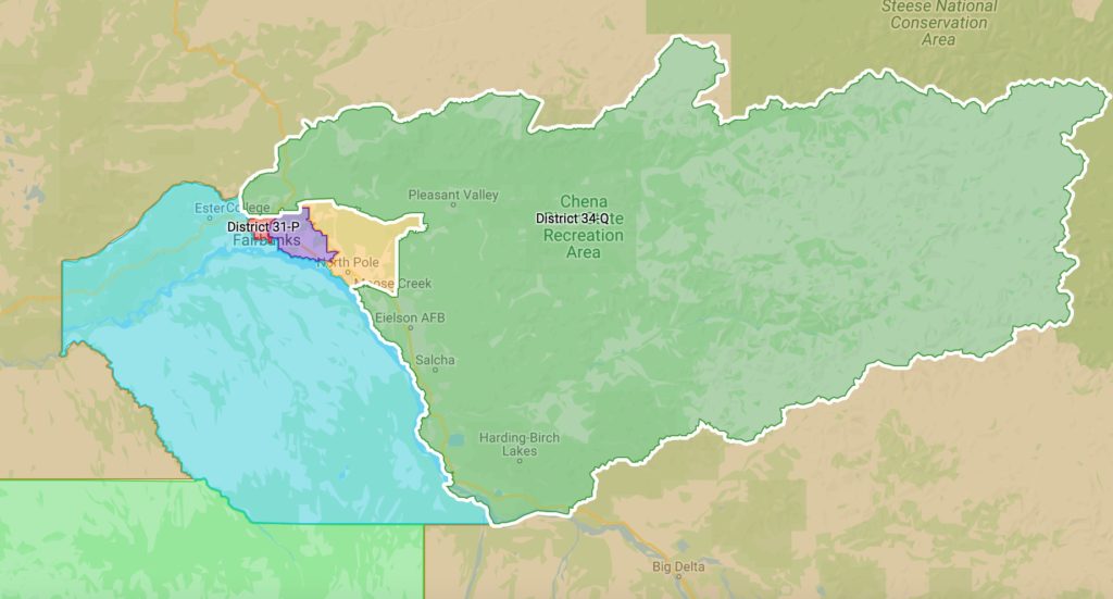
House District 34 – Senate District Q – Steele Creek/Two Rivers/Eielson/Salcha
House District 34 is bounded by a line beginning at the intersection of Farmers Loop Road and Iniakuk Avenue, east on Iniakuk Avenue to Henrik Court, south then southeast to the end of Henrik Court, southeast then east along a non-visible line to RJ Loop, north then east then south to a non-visible line extending west from the intersection of College Road and Alaska Way, east along a non-visible line to College Road, east to the boundary of the City of Fairbanks, east then south then northeast then north then east then north then east then north along the city boundary to a non-visible line extending southeast from the end of Falcon View Street, northwest to the end of Falcon View Street, east then north to Chena Hot Springs Road, east to Hopper Creek, southeast to a winter trail east of Severns Road, east to the Little Chena River, east along the northern bank to a non-visible line just north of a Sled Road, east along a non-visible line to the southern bank of the Little Chena River, south to a Sled Road, east to a non-visible line extending north from Mullen Sough, south along a non-visible line to Mullen
Slough, southeast to the confluence with the Chena River, southwest along the northern bank to a non- visible line just west of the boundary of Eielson Air Force Base, west then south along a non-visible line to the boundary of Eielson Air Force Base, south then west to the Richardson Highway, northwest to the Moose Creek Dam Levee, southwest to the Alaska Railroad, southwest to Dyke Road, south to Piledriver Slough, south across a non-visible line to the northern bank of the Tanana River, southeast along the northern bank to a non-visible line south of Loon Song Lane, southwest along a non-visible line to the southern bank of the Tanana River, southeast to the boundary of the Fairbanks North Star Borough, northeast then north then west along the borough boundary to a non-visible line extending east from the headwaters of Boulder Creek, west along a non-visible line to the headwaters of Boulder Creek, south to the confluence with the north fork of the Chena River, southwest to Chena Hot Springs Road, west to a trail north of Chena Hot Springs Road, west to W Fork Road, northwest to Trapper Loop, southwest then southeast to a trail north of Chena Hot Springs Road, southwest to Chena Hot Springs Road, south to a 4WD road west of Chena Hot Springs Road, south to Angel Creek, west to a non-visible line extending south from the headwaters of Chena Dome Runoff Creek, north then west along a non- visible line to the headwaters of Chena Dome Runoff Creek, west to the little Chena River, southwest to the confluence with Miller Creek, north to Fish Creek, west to Fairbanks Creek Road, north to a small tributary of Fairbanks Creek, south to Fairbanks Creek, west to a non-visible line extending south from unnamed road, north along a non-visible line to an unnamed road, east to a non-visible line extending north from Fairbanks Creek, south along a non-visible line to Fairbanks Creek, west to Fairbanks Creek Road, west then southwest then northwest to Skiland Road, southwest to Pedro Dome Road, west then southwest to an unnamed road, west to a non-visible line extending north from the end of Silver Fox Road, south along a non-visible line to Silver Fox Road, west then southwest to Old Murphy Dome Road, southwest to a trail near the Trans-Alaska Pipeline, south to the Trans-Alaska Pipeline, south to a non- visible line north of Goldstream Creek, west along a non-visible line to Goldstream Creek, southwest to a unnamed lake, southwest along the southern shoreline to Goldstream Creek, west to a non-visible line extending northeast from Ballaine Road, southwest along a non-visible line to Ballaine Road, south to Farmers Loop Road, south to the point of beginning.
House District 35 – Senate District R – College/Ester/Chena Ridge
House District 35 is bounded by a line beginning at the intersection of the boundary of the Fairbanks North Star Borough and the Alaska Railroad, northeast then east then southeast along the railroad to Sheep Creek Road, north to Goldstream Creek, southeast then east to a non-visible line extending north from Miller Hill Road, south along a non-visible line to Miller Hill Road, south to a non-visible line north of Railroad Drive, northeast along a non-visible line to Ballaine Road, south to Farmers Loop Road, south to Iniakuk Avenue, east to Henrik Court, south then southeast to the end of Henrik Court, southeast then east along a non-visible line to RJ Loop, north then east then south to a non-visible line extending west from the intersection of College Road and Alaska Way, east along a non-visible line to College Road, east to the boundary of the City of Fairbanks, southwest along the city boundary to the southern bank of Noyes Slough, south along the southern bank of Noyes Slough to the Chena River, south along a non-visible line to the boundary of the City of Fairbanks, south then west then southeast then east then south then east then north then east then south along the city boundary to the northern bank of the Tanana River, southeast along the northern bank to a non-visible line south of Loon Song Lane, southwest along a non-visible line to the southern bank of the Tanana River, southeast to the boundary of the Fairbanks North Star Borough, west then northwest then north to the point of beginning.
House District 36- Senate District R – Copper River Basin/Delta/Tok/Yukon Drainage
House District 36 is bounded by a line beginning at the intersection of the southern boundary of the North Slope Borough and the Canadian Border, south along the border to the boundary of Chugach
ANRC, northwest then west to the Trans-Alaska Pipeline, north to the northern bank of the Tazlina River, west to Tazlina Lake, southwest along the northern shoreline to the Nelchina River, west to the boundary of the Matanuska-Susitna Borough, north then east then north to the boundary of Doyon ANRC, west to the Denali Highway, west then northwest to the western bank of the Susitna River, south to an unnamed creek south of Snodgrass Lake, west to the boundary of Ahtna ANRC, north then west then north then northeast to the boundary to the Nenana River, southeast then east to the confluence with Buskasna Creek, northeast to the boundary of Ahtna ANRC, south then east to the boundary of Denali Borough, north then east then north to the boundary of the Fairbanks North Star Borough, east then northeast then north then west along the borough boundary to a non-visible line extending east from the headwaters of Boulder Creek, west to the headwaters of Boulder Creek, south to the confluence with the north fork of the Chena River, southwest to Chena Hot Springs Road, west to a trail north of Chena Hot Springs Road, west to W Fork Road, northwest to Trapper Loop, southwest then southeast to a trail north of Chena Hot Springs Road, southwest to Chena Hot Springs Road, south to a 4WD road west of Chena Hot Springs Road, south to Angel Creek, west to a non-visible line extending south from the headwaters of Chena Dome Runoff Creek, north then west along a non-visible line to the headwaters of Chena Dome Runoff Creek, west to the little Chena River, southwest to the confluence with Miller Creek, north to Fish Creek, west to Fairbanks Creek Road, north to a small tributary of Fairbanks Creek, south to Fairbanks Creek, west to a non-visible line extending south from unnamed road, north along a non-visible line to unnamed road, east to a non-visible line extending north from Fairbanks Creek, south along a non-visible line to Fairbanks Creek, west to Fairbanks Creek Road, west then southwest then northwest to Skiland Road, southwest to Pedro Dome Road, west then southwest to an unnamed road, west to a non-visible line extending north from the end of Silver Fox Road, south along a non-visible line to Silver Fox Road, west then southwest to Old Murphy Dome Road, southwest to a trail near the Trans-Alaska Pipeline, south to the Trans-Alaska Pipeline, south to a non-visible line north of Goldstream Creek, west along a non-visible line to Goldstream Creek, southwest to a unnamed lake, southwest along the southern shoreline to Goldstream Creek, west to a non-visible line extending northeast from Ballaine Road, southwest along a non-visible line to Ballaine Road, southwest along a non-visible line to Miller Hill Road north of Railroad Drive, north to the end of Miller Hill Road, north along a non-visible line to Goldstream Creek, west then northwest to Sheep Creek Road, south to the Alaska Railroad, north then west then southwest to the boundary of the Fairbanks North Star Borough, south then southeast to the boundary of the Denali Borough, west then southwest then south to the boundary of the Matanuska-Susitna Borough, south to the boundary of the Doyon ANRC, west then north then northeast then north to the boundary of the North Slope Borough, east then north then east to the point of beginning.
House District 37 – Senate District S – Bristol Bay/Aleutians/Kuspuk
House District 37 includes all uplands and islands bounded by a line beginning at the intersection of the boundary of Doyon ANRC and the western boundary of the Matanuska-Susitna Borough, south then east then southeast along the borough boundary to the centerline of Cook Inlet, southwest then south to a non-visible line west of Diamond Creek, east along a non-visible line to the entrance of Kachemak Bay, south across the entrance to the shoreline near Point Pogibshi, south along the shoreline to the entrance of Port Graham, southeast then southwest then northwest along the northern shoreline of Port Graham to an unnamed creek, southwest to a non-visible line extending east from an unnamed lake on the English Bay River, east along a non-visible line to an unnamed lake, south along the western shoreline to an unnamed creek, west then south to the Mount Bede Ridgeline, northwest to a non- visible line extending southeast from an unnamed creek north of Point Bede, northwest to an unnamed creek, west to the shoreline of Cook Inlet, south to the entrance of Kennedy Entrance, south across the entrance to the boundary of the Kenai Peninsula Borough, west then southwest to the 3-mile limit of the Pacific Ocean near Sukoi Bay, southwest along the 3-mile limit to the boundary of the Lake and
Peninsula Borough, southwest to the boundary of the Aleutians East Borough including Chirikof and the Semedi Islands, southwest then northwest then east around the entire Aleutian Island Chain and the Pribilof Islands to the western boundary of the Bristol Bay ANRC south of Port Heiden, northeast then north then west to the boundary of the Calista ANRC, west then north to a non-visible line north of the Indian River, east then southeast along a non-visible line to the shoreline of the Carter Bay north of the Indian River, south to the mouth of the Indian River, east to the confluence with the north fork of the Indian River, east to the headwaters of the headwaters of the north fork of the Indian River, southeast along a non-visible line to the headwaters of Camp Creek, east to the confluence with Barnum Creek, southeast to the confluence with Native Creek, south to the confluence with the Goodnews River, northeast to Goodnews Lake, northeast along the southern shoreline to Igniumanik Creek, northeast to the boundary of the Bristol Bay ANRC, northeast to the boundary of the Kuspuk School District, northwest then north to the boundary of Doyon ANRC, east to the point of beginning.
House District 38 – Senate District S – Lower Kuskokwim
House District 38 includes all uplands and islands bounded by a line beginning at the boundary of the Kuspuk School District and the southern boundary of the Kusilvak Census Area, southwest along the census area boundary to a non-visible line extending south from the headwaters of the Pitmik River, north along a non-visible line to the Pitmik River, north then west along the southern bank to the confluence with the Kashunuk River, west along the northern bank to the confluence with the Kokechik River, west along the southern bank to the confluence with Komoiarak Slough, southwest to the headwaters of Komoiarak Slough, northwest then southwest along a non-visible line to the eastern boundary of the City of Hooper Bay, south to the shoreline of Hooper Bay, east to a non-visible line extending out east and north from south of the City of Hooper Bay, south then west along a non-visible line to the 3-mile limit of the Bering Sea, south then southwest to a non-visible line north of the Indian River including Saint Matthew and Nunivak Islands, east then southeast along a non-visible line to the shoreline of the Carter Bay north of the Indian River, south to the mouth of the Indian River, east to the confluence with the north fork of the Indian River, east to the headwaters of the headwaters of the north fork of the Indian River, southeast along a non-visible line to the headwaters of Camp Creek, east to the confluence with Barnum Creek, southeast to the confluence with Native Creek, south the confluence with the Goodnews River, northeast to Goodnews Lake, northeast along the southern shoreline to Igniumanik Creek, northeast to the boundary of the Bristol Bay ANRC, northeast to the boundary of the Kuspuk School District, northwest then north to the point of beginning.
House District 39 – Senate District T – Bering Straits/Yukon Delta
House District 39 includes all uplands and islands bounded by a line beginning at the northern-most point for the Bering Straits ANRC, south then east to the boundary of Doyon ANRC, south to the boundary of the Kuspuk School District, south to the boundary of the Kusilvak Census Area, southwest along the census area boundary to a non-visible line extending south from the headwaters of the Pitmik River, north along a non-visible line to the Pitmik River, north then west along the southern bank to the confluence with the Kashunuk River, west along the northern bank to the confluence with the Kokechik River, west along the southern bank to the confluence with Komoiarak Slough, southwest to the headwaters of Komoiarak Slough, northwest then southwest along a non-visible line to the eastern boundary of the City of Hooper Bay, south to the shoreline of Hooper Bay, east to a non-visible line extending out east and north from south of the City of Hooper Bay, south then west along a non-visible line to the 3-mile limit of the Bering Sea, north along the 3-mile limit to the boundary of the Bering Straits ANRC, northeast then west then north including Saint Lawrence and Little Diomede Islands to the point of beginning.
House District 40 – Senate District T – Arctic
House District 40 includes all uplands and islands within the Northwest Arctic Borough and the North Slope Borough.
