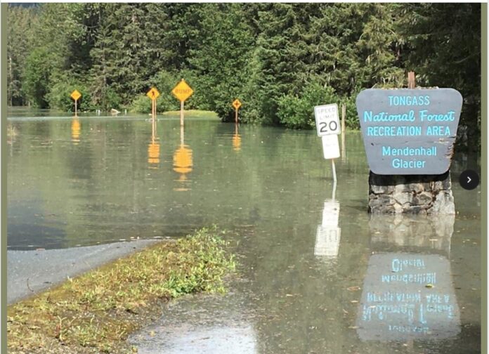
The National Weather Service says the a glacial outburst of water has released from Suicide Basin, to the east side of the Mendenhall Glacier, and a large amount will be in Mendenhall Lake and then Mendenhall River, which is expected to crest near near 15 feet on Tuesday morning.
Last year in the same week in August, a similar event ended up taking one house with it as it gushed down toward Gastineau Channel and damaging others.
Here’s how the flooding will develop, the Weather Service says:
At 9.0 feet: Water starts to cover Skaters Cabin Road between Skaters Cabin and West Glacier Trailhead, also water will flow into the Mendenhall Lake Campground.
At 9.5 feet: Areas along View Dr will start to flood and cause minor flooding of yards. There will be 0.5 feet of water over the Skaters Cabin Road between Skaters Cabin and West Glacier Trailhead. Campsite 7 will be flooded with water starting to flow over the road between campsites 8 and 9 in the Mendenhall Campground.
At 10.0 feet: Water levels will inundate Mendenhall Campground with up to 3 feet of water covering low areas as well as up to 1.5 feet of water covering Skaters Cabin Road. Portions of West Glacier Trail will be impassable.
At 10.5 feet: Significant flooding along the Mendenhall Lake area with more than 3 feet of water in places and the Mendenhall campground will be evacuated. Some homes along View Dr will have up to 3 feet of water in yards.
At 11.0 feet: View Dr will be flooded and impassable with significant flooding to some homes in the area. Locations below back loop bridge will see bank erosion along unreinforced river banks along with hazardous navigation from debris in the river. Homes along the river on Meander Way will begin to see flooding of some backyards. Portions of the Dredge Lake Trail System will be impassable. Flood waters start to reach Dredge Lake.
At 11.5 feet: Houses along the south side and the east end of View Dr will start to flood.
At 12.0 feet: Water starts to back up between Riverside Dr at Tournure St and Mendenhall River School. Significant bank erosion along unreinforced river banks.
At 12.5 feet: 2 to 4 feet of water in some backyards along Meander Way on the the river side.
At 13.0 feet: Water begins to flow through some backyards of homes on the northside of View Dr and flood low lying areas. Locations on View Dr will see depths of 1 to 4 feet of water in homes.
At 13.5 feet: Water will begin to flood at the north end of Meander Way as well as Stream Ct & Northland St from storm drains. Also storm drains along Riverside Dr and Riverwood Dr. start to back up. Severe bank erosion along unreinforced river banks.
At 14.0 feet: Water starts to enter Northland St., Turn St., Stephen Richards Memorial Dr., Parkview and Center Ct. Up to 1 to 2 feet of water will cover Meander Way.
At 14.5 feet: Meander Way will be under 2 to 4 feet of water. Water will start to enter the lowest levels of several homes on Meander Way. Water will start to flow into backyards along Killewich Dr. and onto Riverside Dr. near Melvin Park. Significant flooding of multiple homes along View Dr.
At 15.0 feet: Up to 2 feet of water will be covering Killewich Dr. Water starts to enter the backyards of houses along the south side of Marion Dr. Rivercourt Way, Lakeview Ct., Center Ct., Parkview Ct., Turn St. and Northland St. could have up to 1.5 feet of water over the road. Up to 1 foot of water covering Riverside Dr, at Tournure St.
A flood warning is in effect for the flood areas through 4 p.m. Tuesday.

Was it a smart idea to build – construct homes within the flood plain???
Common Sense, Reason and Logic says … “NO!”
They seem to be a little more proactive this year with evacuations. Seems strange to have flooding when its 80 degrees out but there is a lot of snow melt. At least there’s no torrential rains in the forecast.
Cap City Rescue has a pic on Facebook of water almost up the the entry sign
Thanks, TMA, I popped that one up to the top. – sd
Well, Juneau is known for having frequent, figurative meltdowns.
Maybe if the Feds made more real estate to the people who own the land they wouldn’t have to reside in flood plains? Maybe if the state made more real estate to the people who own the land they wouldn’t have to reside in flood plains?
Part of our unique problem is it’s not just the feds. We have to deal with environmental idiots, native corps, and a faux junta who refuse to do anything outside of build monuments to themselves. Plus the usual locals.
It can take a near act of God at times to be able to clear land.
Looks like the politicians should put the tax dollars into flood control instead of new offices and buildings for them self’s.
Comments are closed.