

The first big storm of the fall season is pummeling Western Alaska, with winds expected to increase in Nome throughout the night, peaking at 3 am on Sept. 17.
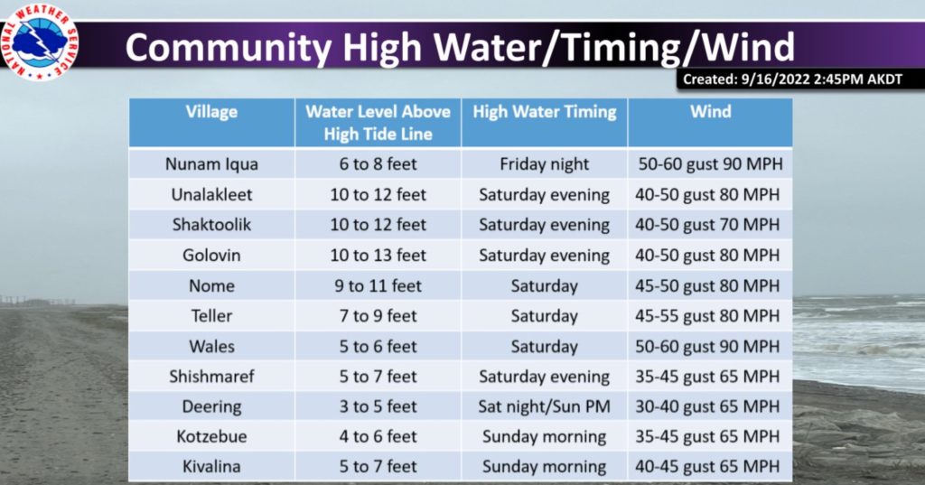
In coastal communities of Elim and Koyuk, around 90 miles from Nome, the water could be as much as 17 feet above the normal high tide line, the National Weather Service warned. In Nome, the water could be 14 feet above normal levels for what is expected to be a multi-day storm.
The buoy 310 nautical miles north of Adak reported waves at or above 35 feet for 12 hours straight today, peaking over 50 feet, the National Weather Service said. Winds gusted to at least 60 knots for 11 straight hours, peaking over 65 knots. Waves north of Adak could reach higher than 54 feet.
AccuWeather reports this is a remnant of Typhoon Merbok, which formed over the northwestern Pacific during the second week of September. It has transitioned to a powerful tropical wind and rainstorm. AccuWeather meteorologists warn the massive storm will hit areas of western Alaska with the force of a hurricane this weekend.
“Even though Tropical Wind and Rainstorm Merbok will gradually lose intensity as it travels northeastward across the Bering Sea and approaches the western coast of Alaska, it will still pack a tremendous punch in terms of wind, seas and precipitation,” the weather site warned.
All flights to and from Nome were canceled on Friday due to the high winds. Bering Air said it would open at 7:15 am Saturday if weather permits.
Check out the Windy.com modeling at this link.
You can watch the weather and waves along Nome’s waterfront at the webcam on Main Street at this link. It refreshes continuously. Here is a clip of what the beach at Nome looked like at 7:30 pm on Sept. 16:
