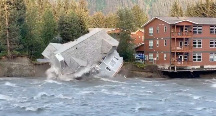
The City and Borough of Juneau issued a public notice warning residents of rising flood risk as Suicide Basin, perched on one side of the Mendenhall Glacier, is approaching levels associated with previous glacial outburst floods.
According to the latest monitoring data, the water level in Suicide Basin has climbed to 1,290 feet, just 44 feet shy of the level that triggered last year’s record-breaking flood on Aug. 6, 2024. Over the past week alone, water levels have risen more than 17 feet, averaging a rapid increase of 2.5 feet per day. If that estimate is true, by Wednesday, the water-ice level will have reached nearly 1,300 feet.
City officials said that if a release occurred today, floodwaters could inundate low-lying areas such as View Drive, potentially reaching homes and making roads impassable. No flood alert has been issued yet, but authorities are maintaining a watch, with a likelihood of another possibly catastrophic flood event in mid-August. This would be during the time when the Alaska Legislature is scheduled to be in special session in Juneau, further adding to Juneau tensions.
In preparation, CBJ and Tlingit & Haida are partnering to host sandbag distribution events at the Dimond Park Field House to help residents protect their properties. The next event is scheduled for Saturday, July 26, from 11 am to 3 pm, with additional events planned later in the month.
A Hesco barrier project is under way along the riverbanks in the areas most prone to flooding, although the Assembly decided not to move forward with the proposed Phase 1B barrier installation until the appropriate funding discussions, community conversations and bank armoring could be completed.
Since 2011, Suicide Basin has regularly unleashed outburst floods, sending torrents of water and debris downstream into Mendenhall Lake and the Mendenhall River. The frequency of these annual floods has increased and the 2024 summer flood season was the most damaging on record, and the latest data suggests the basin is on track to reach similar capacity again this summer.
The US Geological Survey operates two cameras providing four images daily, along with active laser sensors tracking water levels. Officials say that occasional fluctuations in laser data can occur due to large iceberg movements within the sensor’s range.
The latest on-site assessment by the University of Alaska Southeast, conducted on July 14, confirms the rapid water accumulation. By comparison, the basin stood at 1,334 feet at this time last year and 1,370 feet two years ago.
City officials said inflow rates remain highly dependent on weather, with warmer temperatures and rain accelerating the basin filling process. Based on current projections, the basin could reach full capacity, around 1,371 feet, by mid-August, increasing the risk of a sudden release.
